


116
Tip:
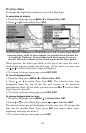
If you wish, you can change the displayed data font size when you
select a data type:
1. From the Map page, press
MENU
|↓ to
O
VERLAY
D
ATA
|
ENT
.
2. Press ↓ or ↑ to select Data Type|press → or ← to select
Data
Size
|
ENT
.
The data will be shown in the new font size. To return to the
previous page, press
EXIT
|
EXIT
.
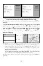
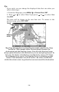
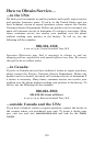
Map Page showing boat cruising Keystone Lake with Overlay Data
turned on. This example shows Ground Speed, Distance (to
destination) and the Steering Arrow. Note that the Steering Arrow
always points directly to the destination you are navigating toward. In
this case, the boater is headed on a northeasterly course of 3º. Since
the helmsman is on course, the Steering Arrow is pointing straight
ahead. If the helmsman veered off course, the arrow would show
which direction to steer to get back on course toward the destination.
Steering
arrow
Speed
Distance