


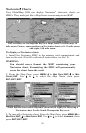
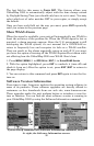
86
(MN), to noon (NN) to midnight (MN). The dotted line across the graph
is the Mean Lower Low Water line (MLLW).
The height scale on the top right side of the graph changes, based upon
the maximum range of the tide for that day. The MLLW line also ad-
justs its position as the height scale changes.
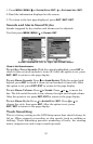
You can look up tidal data for other dates by changing the month, day
and year selection boxes. To select another date:
1. Use → and ← to highlight month, day or year, then press
ENT
.
2. Use ↑ and ↓ to select the desired month, day or year, then press
ENT
.
To clear the information screen, press
EXIT
.
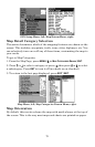
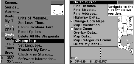
Pop-up Help
Help is available for virtually all of the menu labels on this unit. By
highlighting a menu item and leaving it highlighted for a few seconds, a
"pop-up" message appears that describes the function of the menu item.
This feature is on by default.
To set up Popup Help: Press
MENU
|
MENU
|↓ to
S
YSTEM
S
ETUP
|
ENT
|↓
to
P
OPUP
H
ELP
. With the option highlighted, press
ENT
to check it (turn
on) and uncheck it (turn off.) After the option is set, press
EXIT
|
EXIT
to
return to the page display.
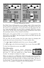
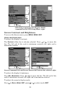
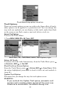
System Setup menu, left, with Pop-up Help command highlighted. At
right, this example shows the Pop-up Help message for the Go To Cur-
sor command, located on the Map Menu.
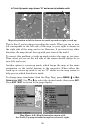
Position Pinning
When you are standing still or moving at extremely slow speed, a GPS
receiver can have trouble determining the direction you are traveling.
In the past, this resulted in a "wandering" plot trail that moved around
the map, even if you were standing still.
The Position Pinning feature was developed so that when you stopped,
the GlobalMap 3200 locked the present position on the GPS plotter un-
til you moved a short distance or exceeded a very slow speed.