


Let’s continue the Getting Started Tour with the map page.
1. Press the J key.
The GPSMAP 135 Sounder’s map page combines digital chartplotting with a
user-selectable display of navigation data and a built-in worldwide database to 64
nm. It will also be the page you use most to create and edit waypoints and routes.
Before we take off on our practice route, let’s take a brief look at its various features
and displays.
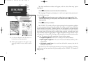
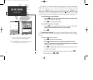
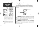
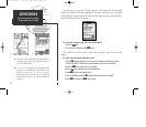
The map display, located in the middle of the page, shows your boat as a trian-
gle marker on an electronically generated chart. Geographic names, markers and
buoys that are provided by the G-chart cartridge you’re currently using are also
shown. It also displays your track, routes and nearby waypoints. An on-screen
cursor lets you pan to other map areas, determine the range and bearing to a posi-
tion, and perform various waypoint and route functions.
The data window, located at the top of the page, provides a user-selectable dis-
play of various navigation data, including course, speed over ground, and bearing
and distance to the cursor or a particular waypoint. The status bar, located at the
bottom of the page, displays the current map scale setting, as well as the status infor-
mation described on page 21.
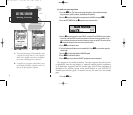
GETTING STARTED
Map Page
Boat
Icon
Data
Fields
Map
Scale
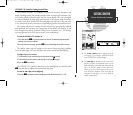
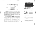
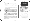
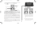
A
B
A. The map/sounder split screen displays cartography
and sounder information at the same time. The split
screen functions as a map page only and any
changes to the sounder display must be made from
the sounder page. Use the QUIT or PAGE key to
quickly switch between the map split-screen and the
sounder page.
B. The map page can also be configured to display
additional data fields and a graphic course devia-
tion scale or compass. See page 40 for more on map
options.
10
GPS 135 Rev C 8/4/98 4:17 PM Page 10