


APPENDIX C
Messages &
Time Offsets
Route Waypoint was Deleted—A route waypoint entered does not exist in the database and
has been deleted from the route.
RTCMInput has Failed—DGPS data being received has been lost. You are no longer receiv-
ing the beacon signal.
Searching the Sky—The GPS 12 is in searching the sky for almanac data or the unit is in
AutoLocate
TM
mode.
Stored Data was Lost—All waypoints, routes, time and almanac data has been lost due to
battery failure or clearing the receiver’s memory.
Track Memory is Full—All track log points in memory have been used. You must either
delete the current tracklog or switch the record option to ‘WRAP’ which will begin erasing the
oldest tracklog points as new ones are added.
Transfer has been Completed—The receiver is finished uploading or downloading informa-
tion to the connected device.
WPT Memory is Full—You have used all 500 waypoints in the GPS 12. Delete unwanted
waypoints to make room for new entries.
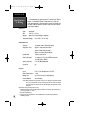
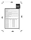
Time Offset Chart
The table below gives approximate UTC time offset for various longitudinal
zones. If you are in daylight savings time, add one hour to the offset.
Longitudinal Zone Offset Longitudinal Zone Offset
W180.0º to W172.5º -12 E007.5º to E022.5º 1
W172.5º to W157.5º -11 E022.5º to E037.5º 2
W157.5º to W142.5º -10 E037.5º to E052.5º 3
W142.5º to W127.5º -9 E052.5º to E067.5º 4
W127.5º to W112.5º -8 E067.5º to E082.5º 5
W112.5º to W097.5º -7 E082.5º to E097.5º 6
W097.5º to W082.5º -6 E097.5º to E112.5º 7
W082.5º to W067.5º -5 E112.5º to E127.5º 8
W067.5º to W052.5º -4 E127.5º to E142.5º 9
W052.5º to W037.5º -3 E142.5º to E157.5º 10
W037.5º to W022.5º -2 E157.5º to E172.5º 11
W022.5º to W007.5º -1 E172.5º to E180.0º 12
W007.5º to E007.5º 0
55
GPS12B 1/13/99 4:29 PM Page 55