


NAVIGATION MENU
27 Binatone Help Line: 0845 345 9677 (for UK only. Local Call rate)
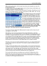
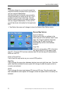
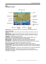
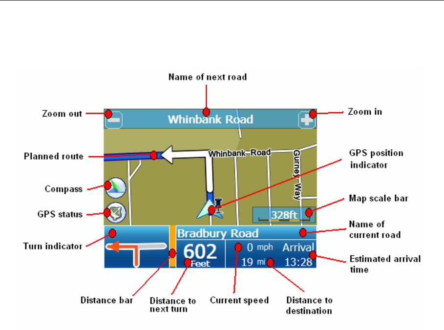
Navi
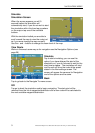
Navigation Screen
Zoom in/out – Tap to either zoom in or out of the map, the map scale bar will
change accordingly.
Name of next road – Shows the name of the road which you will be on after the
next turn.
Planned route – Shows the route ahead which has been calculated by the unit.
GPS position indicator – Shows the vehicles location as the route is travelled.
Compass – Shows the direction of North.
GPS status – Gold means good, grey means poor and that navigation is not
possible. Tap to enter the GPS status screen. (See page 37)
Map scale bar – Indicates the scale for the currently selected zoom level.
Turn indicator – Shows the next manoeuvre/turn that is on the planned.
Distance bar – At 400m from the next turn the bar will begin to turn from orange to
blue, to give you a visual indication of the distance left to travel.
Name of current road – Shows the name of the road you are currently on.
Current speed – Shows the current speed of the vehicle. Note: that this is a general
indication of your speed, always observe you speedometer when checking the speed
of the vehicle.
Distance to destination – Shows the remaining distance to the selected destination.
Estimated arrival time – Shows the time for which you should reach your
destination. The time is constantly being adjusted to take into account the actual
driving/traffic conditions.