


Anhang
Allgemeines Kurzanlei- TourenZieleingabe Zielspeicher Einstellun-
31
Route guidance
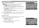
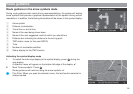
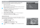
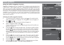
Overview
1 Driving direction arrow indicates the vehicle position and the direction in
which you are travelling.
2 Right-hand information window containing the remaining travel time / arrival
time, distance to the destination and - when coming up to a suggested turn-
ing - the arrow symbol and distance bar.
3 Left-hand information window containing the map scale, TMC station name
and compass rose.
4 The calculated route is indicated in colour on the map display.
5 Name of the road being driven down, time and status display of the TMC
traffic congestion function.
6 Name of the next suggested road into which you should turn.
7 Map information (car parks, petrol station, etc.)
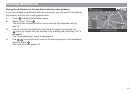
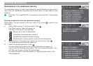
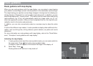
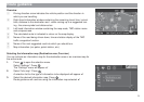
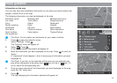
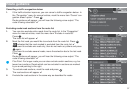
Selecting the information map (Destination area, Overview)
You can activate an information map for the destination area or an overview map for
the entire route.
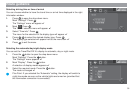
1. Press
OK
to open the selection menu.
Select “Settings”. Press
OK
.
The “Settings” menu will appear. ✔
2. Select “Info map”. Press
.
A selection list for the type of information to be displayed will appear. ✔
3. Select the desired information map. Press
OK
.
Route guidance will continue using the information map selected. ✔
55
55
5
33
33
3
44
44
4
11
11
1
22
22
2
77
77
7
66
66
6